|
| Map
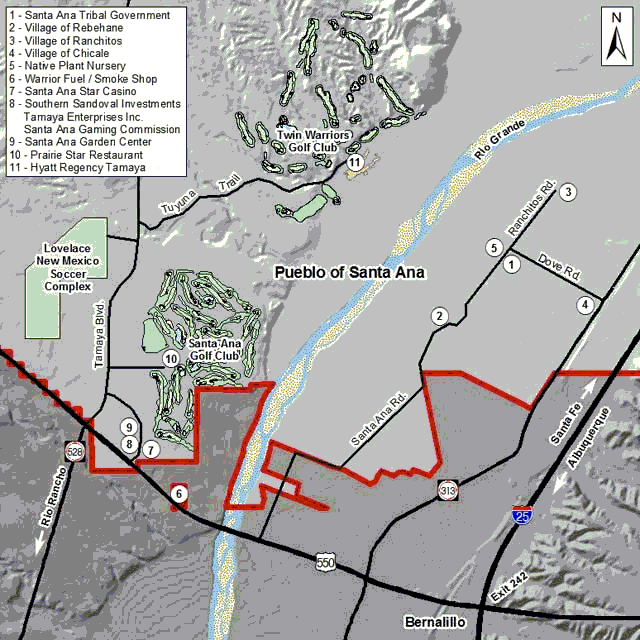
of the Pueblo of Santa Ana Near Bernalillo, NM |
Directions to the Santa Ana Government complex:
From Albuquerque going North on I25
- Take the NM-44 W / NM-165 E exit- EXIT 242- toward RIO RANCHO / PLACITAS.
- Turn LEFT onto US-550 N / NM-165 S / NM-44 W. Continue to follow US-550 N / NM-44 W for 0.6 miles.
- Turn RIGHT onto NM-313 / N CAMINO DEL PUEBLO / PAN AMERICAN CENTRAL HWY. Continue to follow NM-313 for 2.0 miles
- Turn LEFT onto TRIBAL ROAD 77 / DOVE RD and go for 0.5 miles. This is a residential road so go slow and watch for speed bumps.
- Look for the government buildings on the left.
Directions to the Star Casino:
From Albuquerque going North on I25
- Take the NM-44 W / NM-165 E exit- EXIT 242- toward RIO RANCHO / PLACITAS.
- Turn LEFT onto US-550 N / NM-165 S / NM-44 W. Continue to follow US-550 N / NM-44 W for 2 miles.
- Turn Right on Jemez Canyon Dam Rd
- For more information click here
|
 |
|
|
 |
The Pueblo of Santa Ana
2 Dove Road
Pueblo of Santa Ana , New Mexico 87004
USA
(505) 771-6700
|
 |
| Copyright ©
2002, The Pueblo of Santa Ana. |